

 Back
Back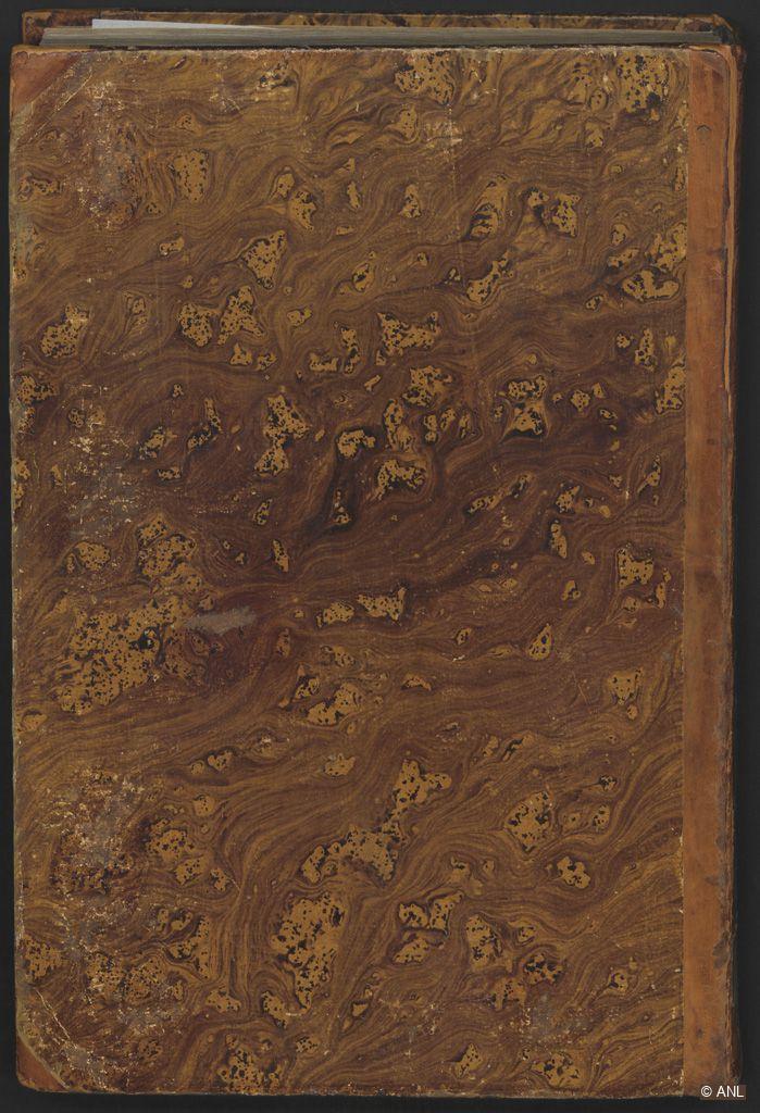
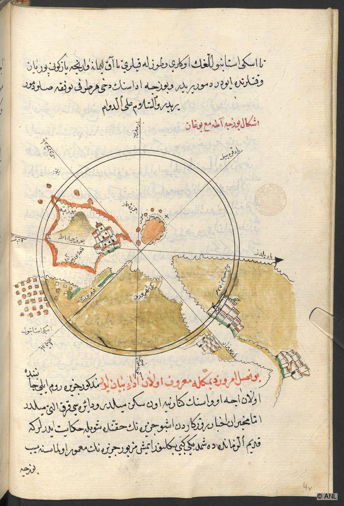
On fol. 4b, the half-page map sketch is situated in the middle of the page between two blocks of texts at the top and bottom. It features a block compass rose in the centre, showing the island of Tenedos, the Dardanelles and the Bosporus. It is coloured in black, light brown, red and green with schematic representations of fortresses and bridges. The island on the upper left shows the great fortress of the Venetians in close proximity to the Dardanelles. On the Bosporus, the Anadoluhisarı (Güzelce Hisar) fortress and the Rumelihisarı fortress (Boğazkesen Castle) can be seen facing each other. The group of islands called Tavşan Adası and Yılan Adası are also visible. Toponyms and additional inscriptions are added to identify the depicted geography.
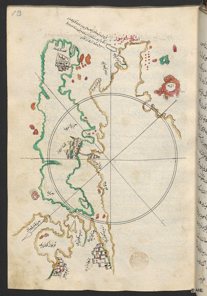
On fol. 13a, the full-page map sketch depicting Euboea or Evia is arranged horizontally with a black compass rose over it. The terrain is an elongated Greek island off the Attic coast, here framed in bright green. Other colours like light ochre and red have also been added to outline or fill in the land masses. Two mighty fortresses are shown on the island as well as on the mainland. The island is connected to the mainland by a bridge, visible in the middle of the page. The formations in red represent small islands, and toponyms and additional inscriptions are added to identify the depicted geography.
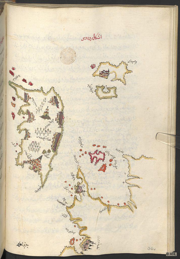
On fol. 36b, the full-page map sketch shows the island of Rhodes. On the lower right, the coast of Anatolia with the fortress of Mermeris is visible. At the top, the island of Chalki is represented with a large three-towered fortress. In the lower part of the island of Rhodes, the Kastello or “Palace of the Grand Master of the Knights of Rhodes” is depicted, while the medieval fortress of Lindos is shown on the upper left. Other fortified places are arranged along the coasts, and numerous tree plantations seem to indicate the fertility of the island. On the right, on the Anatolian coast, the fortified port represented is the village of Serçe Limanı. Toponyms and additional inscriptions are added to identify the depicted geography.
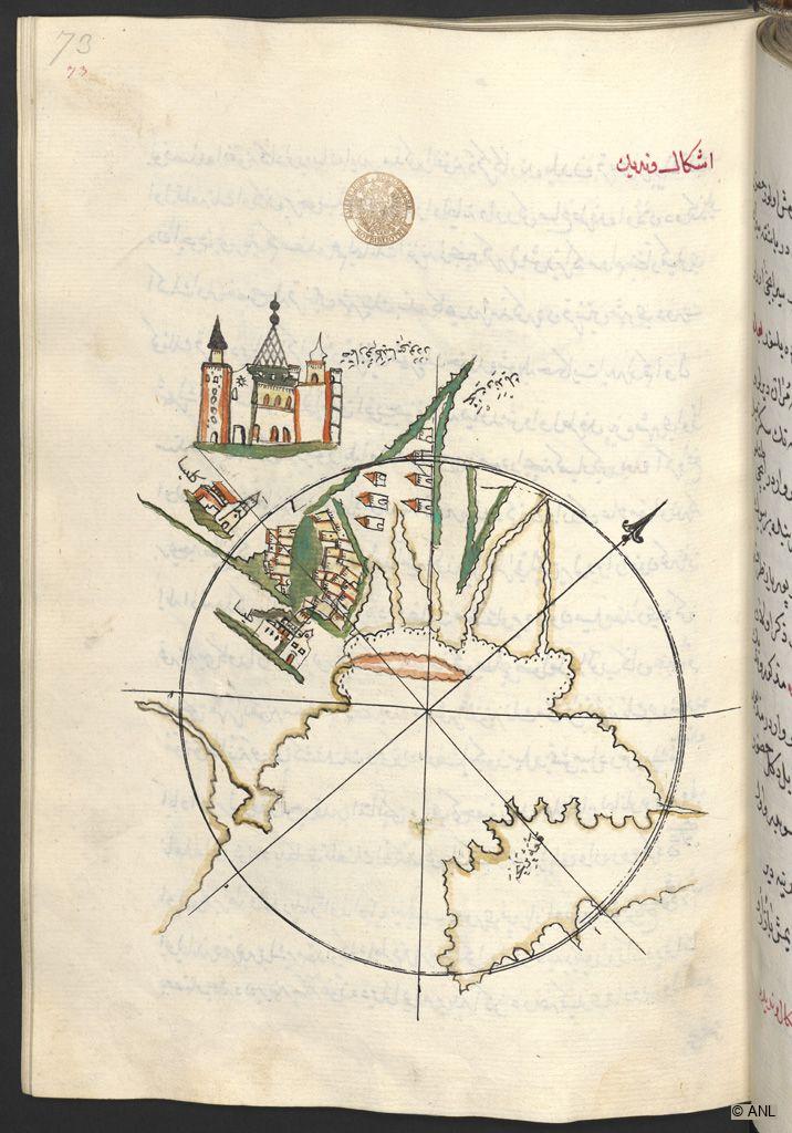
On fol. 73a, the full-page map sketch with a black compass rose shows Venice. At the top, a large building with a conical roof and two side towers is labelled as St. Mark's Church. Below are two other churches on a diagonal axis. The coastline with its incised canals is shown in ochre. A dense cluster of houses and towers in red and yellow indicate the urban area of the city. On the lower right, the peninsula of Istria is depicted, with the Croatian town of Poreč indicated by a toponym.
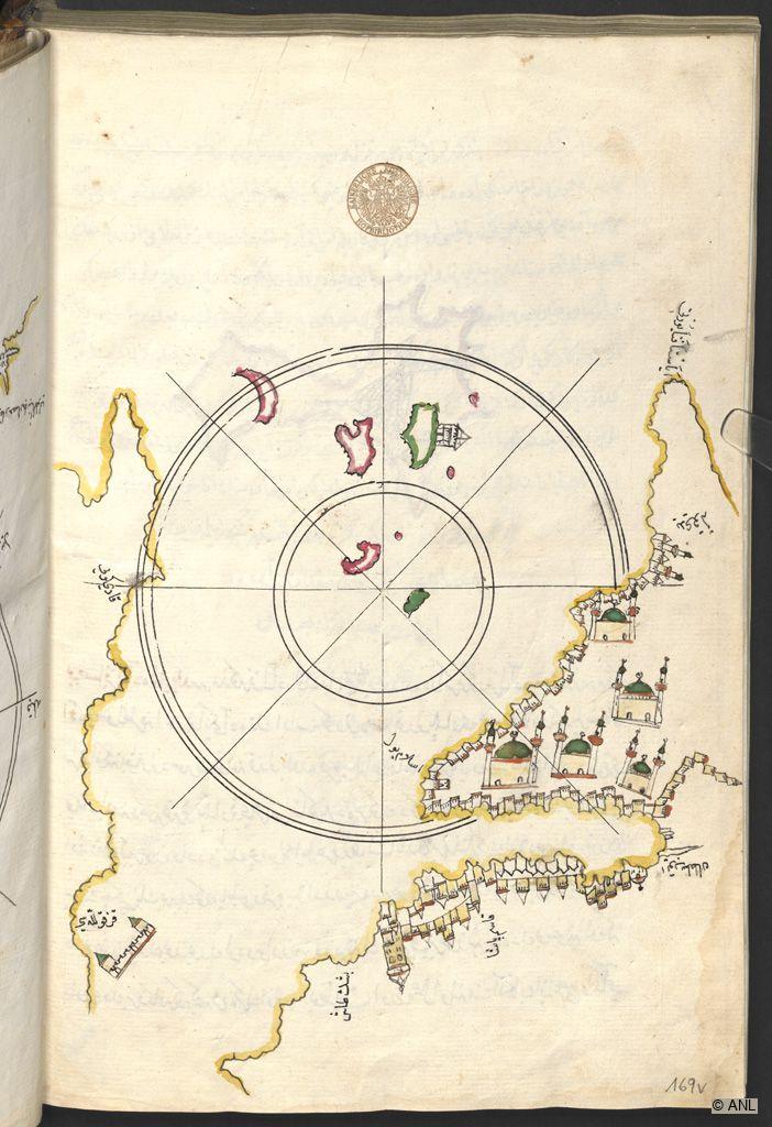
On fol. 169b, the full-page map sketch and a black compass rose show Istanbul with its coastlines outlined in yellow. The Golden Horn and the islands in the Sea of Marmara, such as the Prince's Islands (Qızıl adalar) with the Maiden’s Tower (Kız Kulesi) are visible. On the European side, the city walls and the Galata tower are depicted on the right. Moreover, five mosques are represented in uniform stylization, showing light yellow buildings with a green dome flanked by two slender minarets each. On the opposite Anatolian Side towards Asia, the settlement of Kadıköy is represented to the left. Toponyms were added to identify the depicted geography.
This item has been added to the Database within the Explore Islamic Art Collections project. Information is available in: English, Arabic.
Name of Object:
Piri Reis b. Hajji Mehmed, Bahriye (Navigation or Sailing Manual)
Location:
Vienna, Austria
Holding Museum:
Austrian National Library (ANL)
About Austrian National Library (ANL), Vienna
Date of Object:
Possibly 17th century
Museum Inventory Number:
H.O. 192
Material(s) / Technique(s):
Ink, opaque watercolour and gold on paper. Large calligraphic naskh of 19 lines per page.
Dimensions:
316x220mm (250x155mm), ff. III, II*, 172 folios
Period / Dynasty:
Ottoman
Place of production:
Possibly Istanbul
Binding:
The light brown half-leather binding features the title as well as additional ornaments in gold print on the spine. It consists of European marbled paper over boards, which suggest that it was likely made in 19th-century Vienna.
Description:
The important manual on navigation and sailing called “Bahriye” was authored by Piri Re’is b. Hajji Mehmed (died 962 AH / 1554–55), an Ottoman navigator and cartographer. This 17th-century copy was penned in large naskh script, possibly in Ottoman Istanbul. Piri Re’is, a Turkish captain and later admiral of the Ottoman fleet, is credited with the creation of two famous world maps as well as this sailing manual for the entire Mediterranean. While the latter is relatable to Catalan and Italian Portolane and Isolarii (Sea Atlases or Naval Manuals, and Island Books respectively), the work of Piri Re’is is considered quite independent and original as it contains detailed descriptions of the coasts and islands of the Mediterranean, starting from the Bosporus and the Dardanelles. Interestingly, this manuscript is a late copy of his first version of 1521, while a separate second version, which included a longer and more detailed text, was made five years later and was dedicated to Suleyman the Magnificent. The earlier text consists of 132 chapters with descriptive texts of historical, geographical, and navigational content. Moreover, this copy contains 133 half– to full-page map sketches that accompany the text, of which most feature a black compass rose in the centre. Like the other more than 20 surviving copies, it likely served primarily practical purposes. In contrast, the second version of the text is extant in about ten surviving copies which reflect a representative courtly quality both in their elaborate calligraphy and illustration. This suggests that these manuals were rather intended for the education of the nobility. It has been postulated that the Vienna copy, with its schematic, rather inconsistently oriented sketches that sometimes even extend into the text block, was produced by sailors or members of the Ottoman Navy in the arsenal or in cartographic workshops. The map sketches show port cities and fortresses identified by toponyms and other representational details added in bright colours. These representations seem to follow a fixed compositional formula with stylised landscape depictions. Small offshore islands or reefs, for example, are usually highlighted in red. Judging from the illustrations, this manual is stylistically comparable to the copy kept in the University Library of Bologna (MS 3613, dated 977 AH / 1569 AD), and it has been argued that the Vienna manuscript may be a copy of the Bologna manuscript from the second half of the 17th-century. The owners’ notes and stamps on fol. 1a reveal that the manual was part of the collections of a certain Zeynül'Abidin Evliyazade as well as of Joseph von Hammer-Purgstall.
How Object was obtained:
Purchased from Hammer-Purgstall in 1832.
How provenance was established:
On fol. 1a, the owner's notes and stamps of a Zeynül 'Abidin Evliyazade and of Joseph von Hammer-Purgstall (dated 1223 AH/1808 AD) are visible.
Link to catalogue/digitisation in Holding Institution’s database:
https://data.onb.ac.at/rec/AC14393579
Selected bibliography:
Duda, Dorothea, Islamische Handschriften II/2. Persische Handschriften, Die illuminierten Handschriften und Inkunabeln der Österreichischen Nationalbibliothek, vol. 5/2, Vienna: Verlag der Österreichischen Akademie der Wissenschaften, 2008: 232-242.
Citation of this web page:
Theresa Zischkin "Piri Reis b. Hajji Mehmed, Bahriye (Navigation or Sailing Manual)" in Explore Islamic Art Collections. Museum With No Frontiers, 2026.
https://islamicart.museumwnf.org/database_item.php?id=object;EPM;at;Mus24;13;en
Prepared by: Theresa Zischkin
Copyedited by: Sophie-Anne Mullen
MWNF Working Number: AT4 13
RELATED CONTENT
Islamic Dynasties / Period
On display in
Exhibition(s)
Water in Islam
The Symbolism of Water in sacred Texts, secular Literature, and Science | Water in Knowledge, Science, and TechnologyDownload
As PDF (including images) As Word (text only)