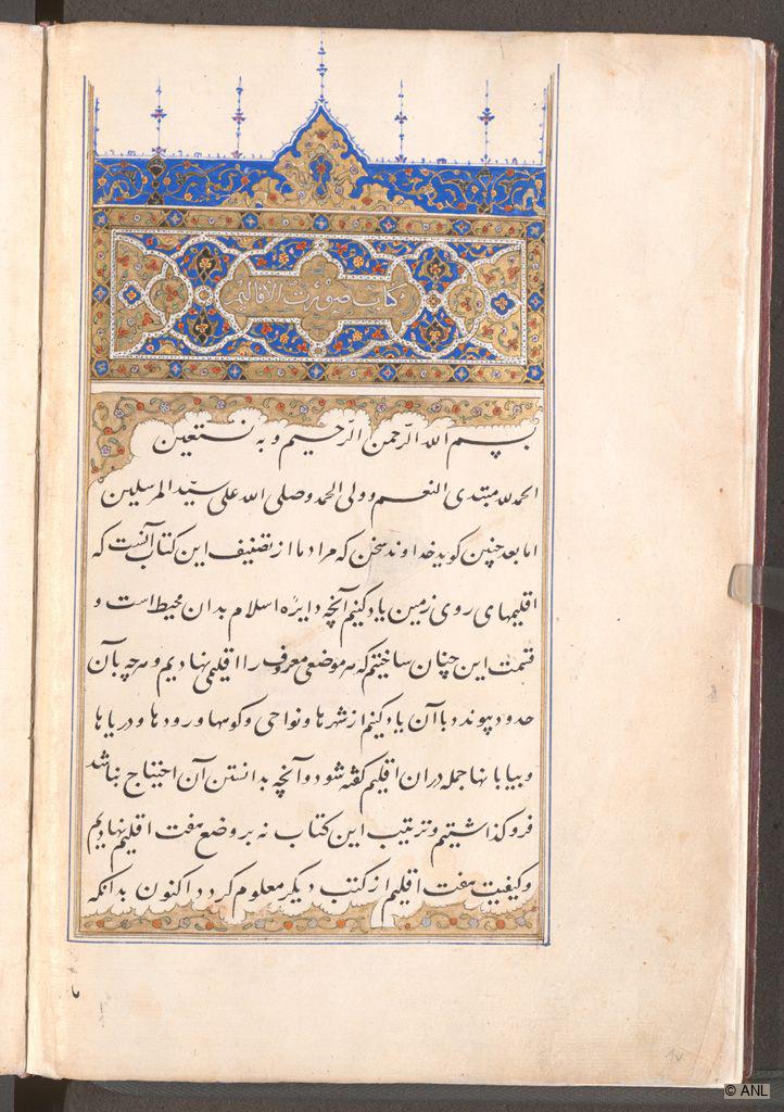
Fol. 1b includes an initial ornamental heading panel (‘unwan/sarlauh) with golden medallions and palmette shapes before a dark blue background filled with small brightly coloured floral scrolls. The central golden panel is inscribed in white with the title of the text. The brightly coloured floral scroll before a golden background extends playfully into the text block underneath, framing the lines of text at the top and at the bottom.
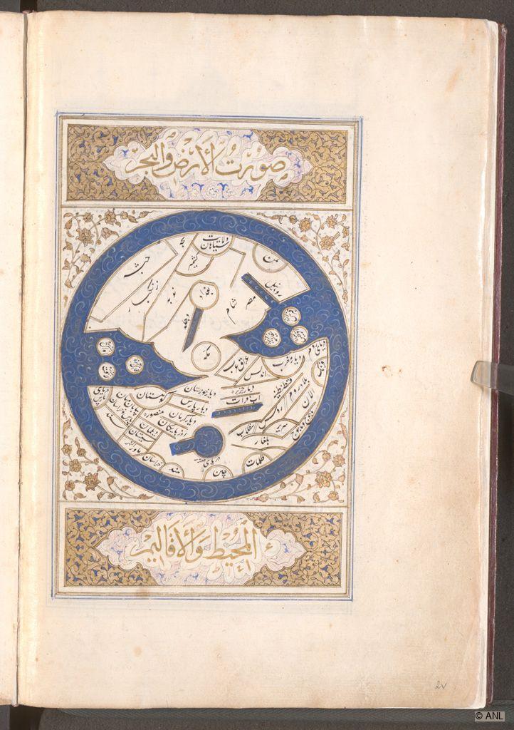
Fol. 2b includes a full-page illustration of the world map, framed at the top and bottom by title panels that are filled with ogival medallions that incorporate large headings in thuluth script, and are surrounded by a dense network of floral patterns. The square panel between them incorporates a roundel with the world map in circular form; the spandrels are filled with golden flowers before a white background. The caption in the panel above reads “Surat al-Ard,” or “picture of the world.” Al-Istakhri begins his treatise with a stylized map of the world preceding all regional maps. Its main purpose was to schematically indicate the position of the regions and their relationship to each other as well as to enable the reader to correctly classify the various regional maps. The circular map shows all known continents at the time, and the outside ring represents the encircling sea, as medieval scholars assumed that the other hemisphere was completely covered with water. The land mass is divided into geometric shapes with toponyms identifying the respective designated places, with Europe shown on the right. The three prominent islands in the Mediterranean Sea are likely Cyprus, Crete and Sicily. Africa is divided at the top by the Nile, which is shown as a straight channel extending upwards. Below the Nile, Egypt (Misr) and Syria (Sham) are indicated, and towards the left, the Indian Ocean opens into the encircling sea. The three circles within the map could be three small islands strategically located in the Persian Gulf. In the bottom left, the region of Khorasan is indicated, and towards the bottom centre, the Caspian Sea, the largest lake on earth, is shown in a keyhole-like shape. The high degree of abstraction of the stylised straight and curved lines in gold emphasises that there was no attempt to reproduce on any actual scale. Possibly, this type of representation served as an aid to memory. Moreover, the map is clearly readable and thus easily reproducible by copyists.
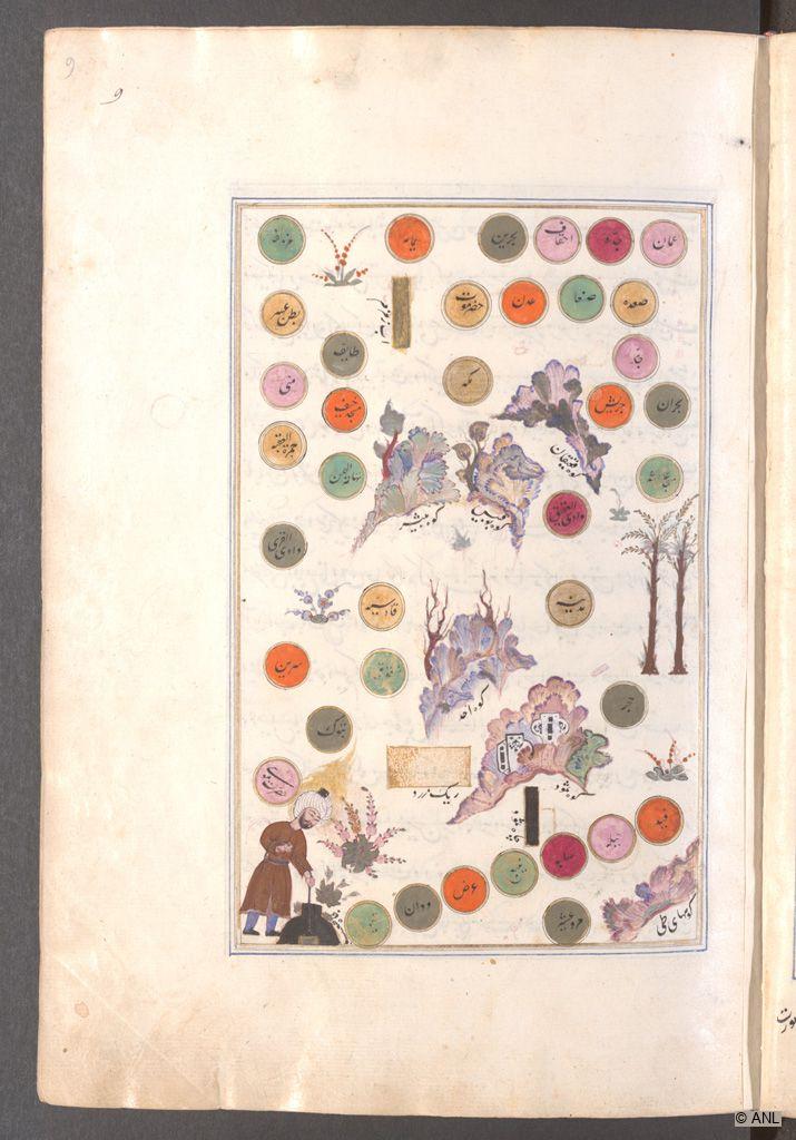
Fol. 9a features the regional map of Arabia. The full-page illustration includes colourful circles with inscribed toponyms possibly designating regions or large cities. These are arranged in a particular formation; for example, in the top right corner, the country of Oman is indicated as a light pink circle while Sana’a, the largest city of Yemen, is represented as a green circle slightly to the left. On the top right, the rectangular block reads “Ab-e Zamzam”, which references the so-called Zamzam Well in the courtyard of the Masjid al-Haram in Mecca. In-between these circles, trees, flowery shrubs and mountain formations with identification markers are incorporated. In the bottom left corner, a man with a golden fiery aureole appears to be involved in some form of manual work.
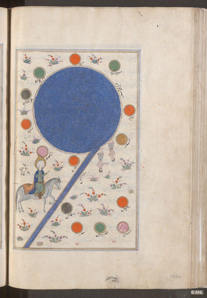
Fol. 102b features the Caspian Sea as a large roundel with wave patterns before a blue background. The depicted river, which has been designated as the “Rud-e Atil”, the Volga, extends to the bottom left corner of the full-page illustration. It is Europe’s longest river, which flows into the Caspian Sea. Next to it, an orange circle with the same name as the river likely denotes the capital city of historical Khazaria. Other colourful circles with added toponyms also designate regions or large cities and in-between them are flowery shrubs arranged in a decorative manner. On the bottom left, a man on a horse is depicted with a fiery aureole. The inscription identifies him as “Hazrat Khizir ‘Ali al-Eslam”, potentially a prophet or guide of mystical journeys. His right hand was either not finished or is deliberately missing. Above his head, the light pink circle represents Abaskun, a medieval port and trading hub on the Volga trade route.
This item has been added to the Database within the Explore Islamic Art Collections project. Information is available in: English, Arabic.
Name of Object:
Abu Ishaq Ibrahim b. Muhammad al-Farisi al-Istakhri, Kitab Suwar al-Aqalim (Book of Images of the Lands)
Location:
Vienna, Austria
Holding Museum:
Austrian National Library (ANL)
About Austrian National Library (ANL), Vienna
Date of Object:
First half of the 16th century
Museum Inventory Number:
Mixtus 344
Material(s) / Technique(s):
Ink, colour and gold on Venetian paper. Calligraphic large ta'liq script of 15 lines per page.
Dimensions:
310x215mm (220x140mm), ff. I, I*, 157 folios
Period / Dynasty:
Ottoman
Place of production:
Possibly Turkey
Binding:
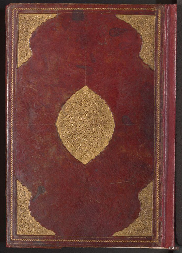
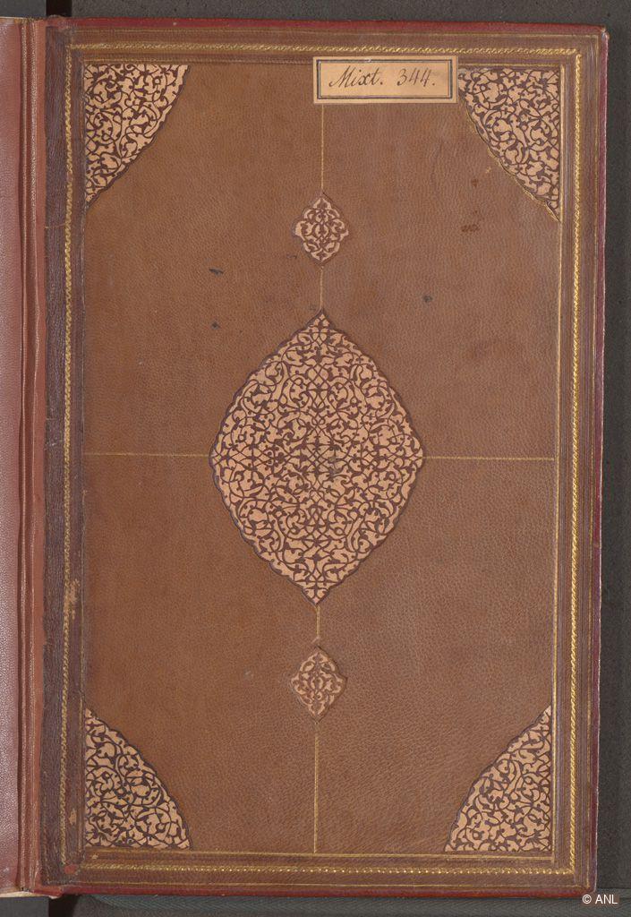
The reddish-brown leather binding includes a flap, and possesses a central medallion and corner spandrels, cut out and executed with gold relief stamping in a floral pattern. The doublures are made of light brown leather with a medallion, two extending pendants and corner spandrels depicted. These motifs are filled with a dense arabesque work in delicate brown leather filigree on a white background. The binding was likely created in 16th-century Turkey.
Description:
The cartographic treatise called “Tarjamat al-Masalik wa al-Mamalik” was written in Arabic by Abu Ishaq Ibrahim b. Muhammad al-Farisi al-Istakhri (c. 340 AH / 951–2 AD), one of the most famous geographers. This 16th-century Persian copy, referred to as “Kitab Suwar al-Aqalim” (Book of Images of the Lands), may have been made in Constantinople or in another centre of Turkish power in the first half of the 16th-century. The colophon offers no contextualising information except for an erroneous attribution of the work to Nasir ad-Din Tusi, who was an astronomer and theologist in the 13th-century. On fol. 1a and 157b, there are two almond-shaped Turkish-Ottoman tughra stamps, with the name of Ahmad Muzaffar Khan indistinctly recognizable. This shows that the manuscript must have been part of Ottoman collections before it came to the Austrian National Library in 1820/30. The text opens with a typical ornamental panel (‘unwan/sarlauh) and includes 21 full-page map illustrations. These brightly coloured miniatures represent stylised maps, occasionally showing decorative motifs, figures, and scenic elements. The quality of the depictions may suggest that they were made by a Persian painter who had emigrated to Turkey. The painter may have also used older models, particularly comparable to a 15th-century manuscript, possibly from Shiraz, in the Topkapı Sarayı (B. 334).
How Object was obtained:
Likely part of the Austrian National Library from 1820/30 onwards.
How provenance was established:
On fol. 1a and 157b, there are two almond-shaped Turkish-Ottoman tughra stamps, with the name of Ahmad Muzaffar Khan indistinctly recognizable.
Link to catalogue/digitisation in Holding Institution’s database:
https://data.onb.ac.at/rec/AC14005879
Selected bibliography:
Duda, Dorothea, Islamische Handschriften I. Persische Handschriften, Die illuminierten Handschriften und Inkunabeln der Österreichischen Nationalbibliothek, vol. 4, Vienna: Verlag der Österreichischen Akademie der Wissenschaften, 1983: 176-180. Rapoport, Yossef, Islamic Maps, Oxford: Bodleian Library, 2020.
Citation of this web page:
Theresa Zischkin "Abu Ishaq Ibrahim b. Muhammad al-Farisi al-Istakhri, Kitab Suwar al-Aqalim (Book of Images of the Lands)" in Explore Islamic Art Collections. Museum With No Frontiers, 2026.
https://islamicart.museumwnf.org/database_item.php?id=object;EPM;at;Mus24;15;en
Prepared by: Theresa Zischkin
Copyedited by: Sophie-Anne Mullen
MWNF Working Number: AT4 15
RELATED CONTENT
Islamic Dynasties / Period
On display in
Exhibition(s)
Water in Islam
The Symbolism of Water in sacred Texts, secular Literature, and Science | Water in Knowledge, Science, and TechnologyDownload
As PDF (including images) As Word (text only)